The trans-American miles were passing quickly under the wheels of my Subaru Crosstrek. Trail miles passed more slowly, although much more pleasantly, under the treads of my hiking boots. On July 20, I had hiked the Turtle Rock Trail near Cheyenne, Wyoming; then, after a zero (hiking) day, I hit the road – and the trail. On the 22nd, after logging five miles in Macbride Nature Center and 686 road miles on I-80 east, I crossed the Mississippi River, cursed the traffic in Chicago Heights and, finally, booked a room in Twinsburg, Ohio. For two nights.

American Germander
Why Twinsburg? Cuyahoga Valley National Park. I had been seeing spectacular pictures from this park on other hiking blogs and longed to check it out. I pass right through it every time I drive to Wisconsin, but my schedule has never allowed time for a stop. Now, the Buckeye State’s only national park was mine for a day, and I had a date with three alluring, effervescent, free-spirited … waterfalls. I wanted to take my time.

The Cuyahoga River
Sandwiched between Cleveland and Akron, Cuyahoga Valley National Park is a rare suburban gem. The 32,572-acre park has no entrance fee. A ranger explained that because the because the park was created in a suburban area, rather than restrict existing roadways, the Park Service just took it on the chin and made it free to the public. I was only a little disappointed that my America the Beautiful National Park Pass was staying in my wallet that day.

Looking west from the parking lot down Boston Mills Road
I parked in a lot just off of Boston Mills Road, about 400 yards east of where I would pick up the Buckeye Trail. I walked down Boston Mills Road, crossing the Cuyahoga River and Riverview Rd. to find the trail. If “Buckeye Trail” is ringing any bells, it’s because it’s one of America’s long-distance trails. Running for 1,444 miles, it circles the state of Ohio and, for over half its length, runs concurrently with one of the country’s longest of long-trails, the 4600-mile North Country Trail. I would spend a scant mile and a half on Ohio’s lengthiest footpath.
 The blue-blazed Buckeye starts off uphill through dense forest. This really wasn’t a very big hill, but as I powered upward, I could feel some of my stamina returning after a long winter off the trail. The day was sunny and in the mid 70s. Perfect. I had been happily lagging behind the heat wave that was sweeping across the United States. With every hike I took, from San Francisco all the way to Cleveland, I enjoyed temperatures below 80ºF. Meanwhile, points only a few hundred miles east of me were suffering triple-digit temps. I feel only a little guilty.
 I came to a ridge overlooking a ravine. I was headed down a particularly steep descent which was aided by a flight of 86 wooden stairs. There are few things slipperier than wet, mossy lumber. I didn’t fall. Once at the bottom, I had to navigate a section of mud-choked trail before climbing up and out.

Eighty-six steps lead down.
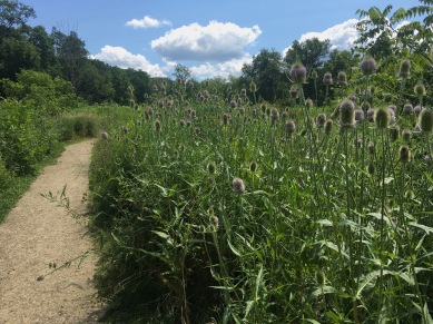
The trail exited the woods and into an open area full of blossoming clover, chicory, and birdsfoot trefoil. I passed a small frog pond and flanked Boston Mills Road (still going west) for about a hundred yards.

 Back into the woods, the trail was lined with tall white yarrow, tiny, delicate white avins, and periwinkle chicory. I was soon deposited into an overflow parking lot where I turned right, crossed Boston Mills Road again, and headed down a wide, dirt jeep-road toward Blue Hen Falls. Fifty yards down the trail, I crossed a bridge over Spring Creek, and the trail shrank to single-track. The falls was fifty yards ahead.

The bridge over Spring Creek
Note: As I approached the falls, I came upon a ranger installing a device on a tree next to the trail. I asked what she was doing. She was installing a people-counter! Cuyahoga National Park is embarking on a visitor management project to determine how to best serve the two-million visitors they have every year. Many TripAdvisor one-star reviews are due to overcrowding. Regardless, there was only one other family at the falls when I visited.
 Blue Hen Falls slides in a shimmering sheet from a smooth rock ledge, fifteen feet above a semi-circular basin. Spring Creek tumbles prettily over a one or two-foot fall just upstream of the main cataract, and the view from the trail is splendid. Many websites refer to Blue Hen as the “prettiest falls in Cuyahoga National Park”. I might agree. Climbing down into the basin is a bit treacherous but worth the effort to view the falls straight on. I shared my time at the falls with a family from Burgundy, France, chatting for a few moments with the parents as their teens clambered over the rocks surrounding the plunge basin.

Blue Hen Falls


 I continued downstream toward the second waterfall of the hike. This trail is unofficial; it is well used and easy to follow, but it is not maintained. Expect to climb over logs and duck under low hanging branches before the trail begins to track away from Interstate 271. Having left the road noise behind, I crossed Spring Creek via a large fallen log, before continuing downstream. The path got a bit rugged, and on one occasion required me to scramble up a bank by grabbing a root and pulling myself up. This dislodged my water bottle from my daypack. The bottle rolled down the bank directly into the creek. Grumbling, I climbed into the ravine, retrieved the water bottle, then hauled myself back out again by the root. The remaining creek crossings were all easy rock-hops across shallow water.
 Even Buttermilk Falls, a twenty-foot cascading waterfall that spills over another smooth, limestone ledge, was an easy crossing. The water was so shallow at the top of the falls (or it was the day I was there) that I easily waded across the top without wetting my boots more than an inch above the soles. The crossing was a wasted effort as there were no spectacular views of the falls from above. Back the trail, I descended to creek level and doubled back upstream fifty yards to see the falls from below. True to its name, the falls rushed milky-white down the gray limestone into a small basin.

Buttermilk Falls

 Beyond the falls, the trail crossed the small creek a couple more times. On one such crossing, I found my way blocked by a small, harmless, but surprisingly feisty, northern water snake. It was only about 2 feet long, but looked ready for a fight. I gave it some space and took another way across. A little farther down the trail, I found myself back in civilization.
This was the Boston Mills and Brandywine Ski Resort. A docent had advised me that I’d need to cross this private property on my proposed circuit. He said that the owners were fine with hikers as long as they remained respectful. I did. Staying close to the creek until I passed the lodge, I came to Riverview Road. Turning right (south), I followed Riverview back to Boston Mills Road. I turned left (east) and crossed back over the Cuyahoga River before turning north on the Ohio and Erie Canal towpath, a few paces beyond the bridge.
 The Ohio and Erie towpath, like all of its ilk, is long, straight … and riddled with disagreeably self-interested cyclists who keep “forgetting” that some people choose to walk. However, even inconsiderate wiry men in spandex could not subvert my mood. Frogs croaked, birds sang, and the breeze wafted gently through the trees as I strolled the couple hundred yards up the towpath to the Stanford Trail. I found it just past a concrete mile marker numbered “21”.
 Turning right (east), I entered an open area of tall grasses and brush. Tall elecampane flanked the trail, yellow against a light blue sky. I followed the path out of the field and onto a driveway, continuing up to, and past, the Stanford House. I found the continuation of the trail to the left of a large, brown barn.


The continuation of the trail
 Here, the Stanford Trail is flanked by tall yarrow and Fuller’s teasel. After about a quarter of a mile, the trail winds its way into an area that is more woods than meadow. I wound my way upward through a forest of hickory and oak, enjoying the cool shade. At the junction of the Stanford and Brandywine Falls trails, I stayed straight on a connector. This allowed me to pass by Avril Pond and loop back to Brandywine Falls, the main attraction of the Three Waterfalls Hike. At the pond, I was greeted (or warned off – it was impossible to tell) by another cacophonous chorus of croaking amphibians.

Avril Pond
When the connector trail intersected Stanford Road, I turned right, following the road for a few hundred yards past black-eyed Susan, evening primrose, and copious chicory. At the bottom of a hill, I turned back into woods and onto trail. I was on the Brandywine Gorge Trail for only fifteen yards when I crossed the Brandywine River via a long, narrow foot bridge. Then the trail snaked through more forest, working its way upstream.

The Brandywine River
Rock-covered and root-choked, the Brandywine Gorge Trail began to climb out of the gorge. Soon, I was eighty or ninety feet above the Brandywine River. My path briefly turned to asphalt, and I crossed a bridge at the head of Brandywine Falls.

From the top of the falls
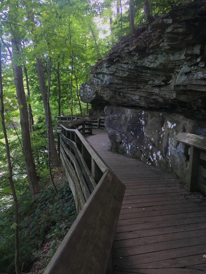
I turned downstream and onto the Upper Boardwalk. This network of steps and catwalks provided good vantage points from which to view the falls. One must go a good way beyond the first view point to find the the turn-off to the Lower Boardwalk. This planked pathway clings to the gorge walls and provides stellar views into the Brandywine Gorge. Expect to descend sixty-nine stairs on your way to the lower viewing platform. It is, however, totally worth it. Here are some pictures. You’re welcome.

From the upper boardwalk

Brandywine Falls
 The sixty-five-foot Brandywine Falls cascades down a small mountain of limestone. Some chutes free-fall nearly the entire height of the falls, while others crash onto a ledge a third of the way down before tumbling to the basin below. On this day, some crazy people were repelling down the side of the falls.
 Back at the top of the gorge, the trail continued as boardwalk for a while before coming to a parking area. I turned right and headed down a wide gravel path. I was back on the Stanford Trail and followed it back to the house, where I turned down Stanford Road and headed back to the parking area. The other option was returning to the cyclist-ridden towpath. There were lots of wildflowers along the road, and it was perfectly pleasant … but it was road hiking.
I can now highly recommend Cuyahoga National Park and the Three Waterfalls Loop. Considering the park hosts two-million visitors a year, my hike included a surprising amount of alone time. That is not to say that this is, by any stretch of the imagination, a solitary hike, but you’ll notice that I was able to get pictures of almost everything sans tourists. Plus, at a ticket price of zero dollars, it would be a great deal even if there weren’t a trifecta of winsome waterfalls connected by wildflower-laden trail. But there are. ♦
Date: July 23, 2019
Location: Peninsula, OH
Trailhead: 41.262336, -81.561649
Distance: 8.5 miles
Elevation Gain: 759 feet
Difficulty: Moderate

Pingback: Upper Burro Mesa Pour-off Trail: The Gift of the Cacti | BIT|Hiker
Great detail and pictures of your hike!
LikeLiked by 1 person
Thank you!
LikeLiked by 1 person
Pingback: Switchback Jacks, Trail Hogs, and Trash Trolls | BIT|Hiker